Holistic approach to water system Assen
In the face of climate change, extreme rainfall events are becoming more intense. The municipality of Assen aims to effectively increase the flood resilience of the urbanized environment. To mitigate flood risk in urban areas, a variety of adaptive measures can be implemented in the water system. However, insights into the interactions between the open water system, the urban drainage system, and the urban space are deemed necessary to adequately align efforts to increase the climate resiliency. The effectiveness of mitigation measures can only be assessed if these interactions are understood.
The challenge
The necessary insights should assess the vulnerability of Assen to current extreme precipitation events, as well as projected future extreme precipitation. The interaction between the open water system, the urban drainage system, and the urban built environment intrinsically brings complex interdependencies. The flow of water inside the city borders alternates between open channels and the sewerage system. Combined, they regulate the in- and outflow of water within the urban domain. Another complex part of this water system is the connection between the urban system and the rural system. There are several locations where exchange between both systems is possible. Sometimes, the same drop of water can enter and leave the urban area within the same simulation, contributing to the importance of a holistic view of the system.
Since the assessment is based on current extreme rainfall events and projected extreme precipitation for future climate scenarios, it is essential to be able to assess multiple scenarios within a relatively short period of time. Hence, the ability to quickly implement mitigation measures and other adjustments (such as adjusted settings to control structures) to a model are as important as having a relatively short calculation time. The focus is therefore on implementing all aspects relating to the water system in detail, whilst running an artificial design event (‘composietbui’) which represents an event with a 100-year return period for every duration.
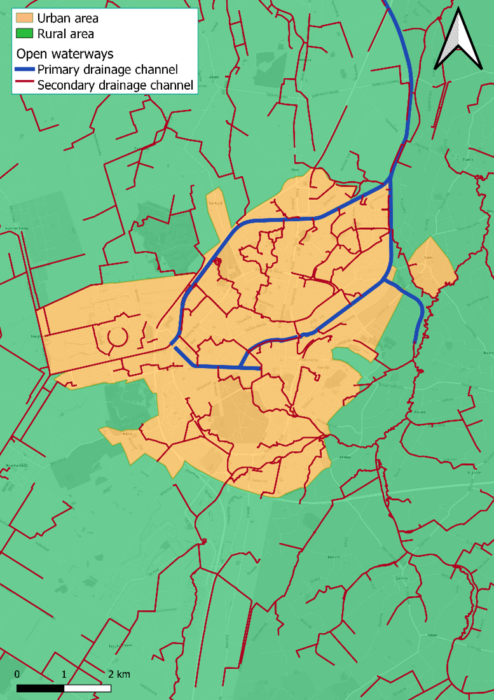
Urban and rural area of Assen
Furthermore, the Assen region consists of both urbanized and rural areas. The rural area drains water to the primary drainage channels, which run through the urban area of Assen, as shown in the figure above. The primary (and secondary) drainage channels – including the control structures – should therefore be included in the assessment. This is necessary to adequately follow the flow of water during the extreme rainfall event and follow the peak discharges from different sub-catchments into the same downstream drainage channel.
Since the urban area consists of a mix of combined sewer systems as well as separate sewer systems, the piped network has to be implemented in its entirety. The houses should be connected to the stormwater system in districts where the separate sewer system has already been implemented. However, in the districts where the combined sewer system is in place, the households are connected to this system.
As mentioned, the arrival time of drained water from the sub-catchments into the drainage channel is a key component of this assessment. Since it is about the effective use of mitigation measures, it is crucial to understand when peak discharges will arrive at bottlenecks in the system. If it is assumed that all peak discharges will arrive at a bottleneck at the same time, mitigation measures will be significantly over-dimensioned. To have this time-component included in an assessment of a water system comprising of open waterways, urban drainage systems and urban space where overland flow is of significance, hydrodynamic modelling brings about a solution that is able to provide insights which cannot be encapsulated in traditional modelling practices.
The above-mentioned criteria present the need for a holistic approach. A comprehensive model of the open water system, urban drainage system, and urban space is necessary. An integrated model which incorporates these three fundamental categories, as well as control structures, can be used to effectively assess the effectiveness of mitigation measures for extreme precipitation events.
Our solution
To comprise the complexity of water distribution through the drainage systems, an integrated (0D-1D-2D) 3Di model was built, as presented in the figure below. Note that these figures show the open water system with the digital elevation model as separate from the urban drainage system. Yet, in the actual model, these are all included in the same integral model.
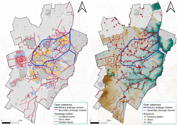
Urban drainage infrastructure with open water system (left) and DEM with open system including control structures (right)
The urban piped 1D-network is modelled as separate stormwater, sewage, and combined sewage systems. The buildings are included in 0D and connect to the piped 1D-network. These connections are automatically generated with tooling which determines whether a building is connected to the stormwater system (separated systems) or the combined sewage system. Manholes are automatically placed at the right elevation level based on the underlying Digital Elevation Model data.
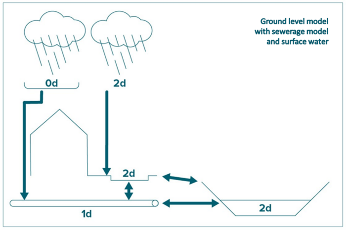
Schematic representation of 0D, 1D and 2D domains as applied in the 3D model. Source: Rioned.
The temporal behaviour of the systems is included by running a simulation which includes not only the precipitation event itself but also the subsequent discharge through the systems. This makes it possible to gain fundamental insight into the effectiveness of mitigation measures. Moreover, control structures are included as essential aspect of the model. These act on certain conditions of the system (e.g., water level, discharge) to determine the direction of flow, among others.
The result
The 3Di model of Assen has helped the municipality and waterboard into working together to find the most effective locations for buffering peak water discharges, attenuating flow, and determining where water storage facilities are most effective. An important insight into the water system was the timing of peak discharges and the movement thereof through the integrated systems.
Water storage facilities in locations where peak discharges arrived after each other now require less storage capacity as expected to be necessary, and mitigation measures can be taken to attenuate flow in either the open water system or the urban areas to ensure peak discharges arrive at different times. This decreases the risk of flooding whilst minimizing the storage capacity necessary in locations where space is scarce. Also, significant cost reductions can be obtained since storage facilities have reduced size.
The extensive modelling process resulted in a valuable set of models for the Municipality of Assen for future scenario analyses. Through running the integrated model for different scenarios, potential risk areas and effective mitigation measures have been derived. Consequently, the effective use of public space, underground storage space, increased storage capacity in the drainage system, or increased buffer capacity in the open waterways can be co-designed to reach a holistic solution for the greater region.
The specifications of the model used are the following. The model has a calculation time of approximately 8 hours for a scenario with a total simulated time of 4 hours. This model contains 314.000 calculation nodes.