Optimizing Water Distribution in Catchments During Drought with 3Di

Optimizing Water Distribution in Catchments During Drought with 3Di
3Di users use hydrodynamic modelling for drought mitigation analysis to:
- Easily simulate many scenario’s for better understanding the working of the water system
- Easily work with different states of hydrological history
- Easily integrate with existing ground water instruments, like Modflow.
- Execute what-if analysis on the fly, live and interactive.
As climate change continues to bring more extreme weather patterns, droughts are becoming increasingly common, posing serious challenges for water management. Efficient water distribution during these dry periods is essential for agriculture, ecosystems, and urban water supply. Understanding how water is stored and moves through catchment areas, particularly under drought conditions, is key to making informed decisions. This is where 3Di provides a cutting-edge solution for hydrodynamic modeling, offering detailed insights into the water distribution system and helping experts plan effective interventions.

The Key Elements in Water Distribution During Drought
Water distribution in catchments during drought is influenced by three critical factors:
1. The Network of waterways: The layout, connectivity, and density of waterways play a major role in determining water movement and storage. Understanding whether these systems have drainage, how they interact with surface water, and whether water can be brought in from other areas is fundamental to managing water efficiently.
2. Hydrological History: What happens before a drought sets in is crucial. The history of water levels in the soil and watercourses can greatly affect how a system behaves under dry conditions. For instance, a catchment that experienced a wet period may have more resilience during the drought compared to one that has been dry for an extended time.
3. Groundwater Dynamics: The movement of groundwater, whether it is seeping into watercourses or draining away, is critical for understanding the broader water availability during drought. This dynamic can vary depending on whether the region is high or low-lying and whether there is groundwater upwelling or percolation occurring.

Using 3Di to Understand Water Distribution
The 3Di hydrodynamic model is a powerful tool designed to give water experts a clear understanding of how water moves through different systems, including surface water, groundwater, and drainage networks. Here’s how 3Di supports each of the three key elements:
1) The Watercourse Network
One of the biggest advantages of 3Di is its ability to map the watercourse network in great spatial detail, incorporating everything from small ditches to large streams. The model accounts for the interaction between surface water and groundwater, including drainage or infiltration. Using high-resolution data like the 0.25m² elevation map of the Netherlands, 3Di integrates even the smallest depressions and low-lying areas into its 2D model, providing a comprehensive view of the landscape.
With 3Di, water expertss can simulate different scenarios, such as raising water levels, closing off ditches, or creating water buffers by reducing drainage flow. These simulations allow for data-driven decision-making on water distribution and drought mitigation measures. Additionally, unlike many other models, thanks to the subgrid technique, 3Di remains efficient and accurate even when watercourses dry up, which is a common occurrence during long periods of drought.
2) Hydrological History
A catchment’s hydrological history plays a crucial role in determining how it responds to drought. Whether a region has recently experienced a wet or dry period affects soil moisture levels and water availability in the watercourses. 3Di allows for flexible modeling by taking into account different hydrological scenarios and making them the starting point for future calculations.
Water experts can save different ‘states’ of hydrological history in 3Di, including water levels and volumes, and use them to simulate how different drought scenarios would affect the water system. This feature is particularly useful for planning, as it allows experts to explore a range of outcomes depending on the catchment’s prior conditions.
3) Groundwater Dynamics
Groundwater is a vital water source during drought, and its movement within a catchment is largely influenced by the geohydrological structure. 3Di distinguishes between phreatic groundwater (close to the surface) and deeper groundwater systems. The model simulates the interaction between surface water and groundwater, offering a full 2D calculation of the phreatic groundwater up to a resolution of 0.25m².
3Di also supports the integration of deep groundwater models like ModFlow, allowing for even more detailed assessments of groundwater flow and how it influences water availability in a catchment. By simulating the effects of drought, 3Di helps experts understand whether groundwater is rising into watercourses or draining away, providing insights for making more informed decisions. Modeling Drought Mitigation Measures
Mitigation measures
With an integrated spatial model validated under various hydrological conditions, water experts can explore a wide range of strategies to optimize water distribution during drought. 3Di focuses primarily on short-term, spatial water distribution measures within a hydrological year or growing season, where quick interventions are most effective.
Some examples of drought mitigation measures that can be modeled in 3Di include:
- Stopping irrigation from phreatic groundwater or surface water.
- Removing pipe drains from fields to assess the effect on groundwater levels.
- Filling in ditches to evaluate how this impacts groundwater and surface water levels.
- Introducing surface water from external sources and modeling its spread throughout the water system.
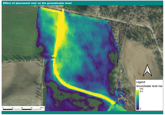
- Raising water levels and calculating how this affects phreatic groundwater.
- Increasing urban infiltration and assessing its effect on groundwater levels.
By providing a detailed, spatial view of how these measures impact water distribution, 3Di gives experts the insight needed to make better decisions for water allocation during drought.